
This is the official website of The Vancouver East Conservative Electoral District Association.
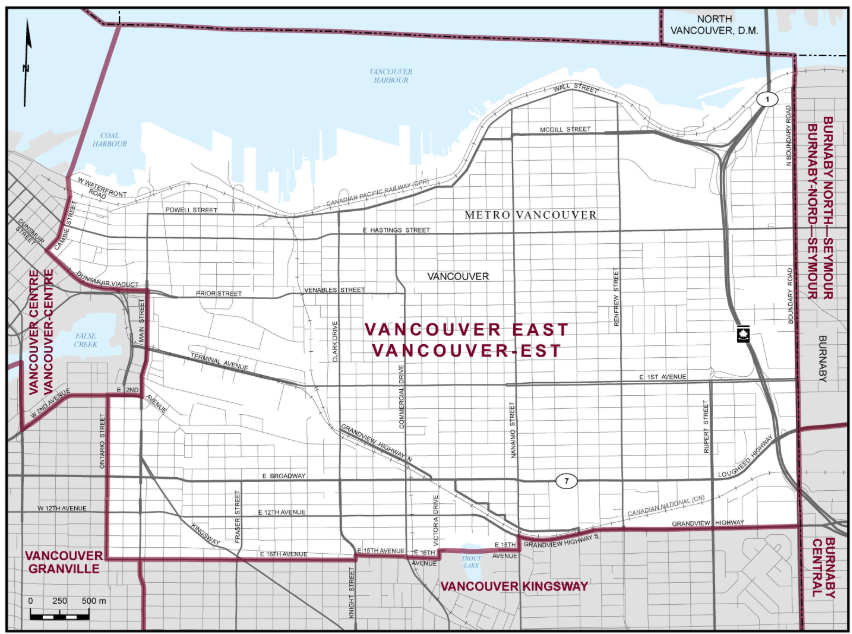
Boundaries Description
Consists of that part of the Metro Vancouver Regional District comprising that part of the City of Vancouver lying northerly and easterly of a line described as follows: commencing at the intersection of the easterly limit of said city and Grandview Highway; thence generally westerly along said highway and Grandview Highway South to Nanaimo Street; thence southerly along said street to East 15th Avenue; thence westerly along said avenue and its intermittent production to Victoria Drive; thence southerly along said drive to East 16th Avenue; thence westerly along said avenue, its production and East 15th Avenue to Knight Street; thence southerly along said street to East 16th Avenue; thence westerly along said avenue and its intermitent production to Ontario Street; thence northerly along said street and its intermittent production to East 2nd Avenue; thence easterly along said avenue to Main Street; thence northerly along said street to Dunsmuir Viaduct; thence westerly and northwesterly along said viaduct and Dunsmuir Street to Cambie Street; thence northeasterly and northerly along said street to its end point; thence northerly in a straight line to a point on Waterfront Road West at approximate latitude 49°17’10″N and longitude 123°06’32″W; thence northerly in a straight line to the intersection of the northerly limit of said city and the southwest corner of the City of North Vancouver.